H2O-Net: Self-Supervised Flood Segmentation via Adversarial Domain Adaptation and Label Refinement
Proceedings of the IEEE/CVF Winter Conference on Applications of Computer Vision, 2021
Peri Akiva, Matthew Purri, Kristin Dana, Beth Tellman, Tyler Anderson
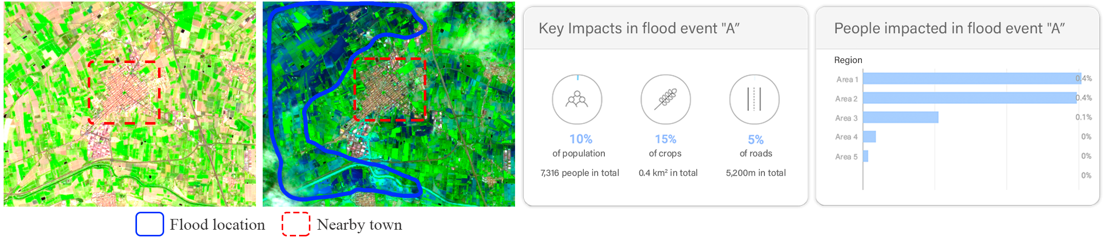
Illustration of our method's use-case. Flood segmentation combined with information about per-pixel population density and infrastructure locations can help assess damages and response in future events. Numbers in this example are for demonstration purposes and do not reflect real events.
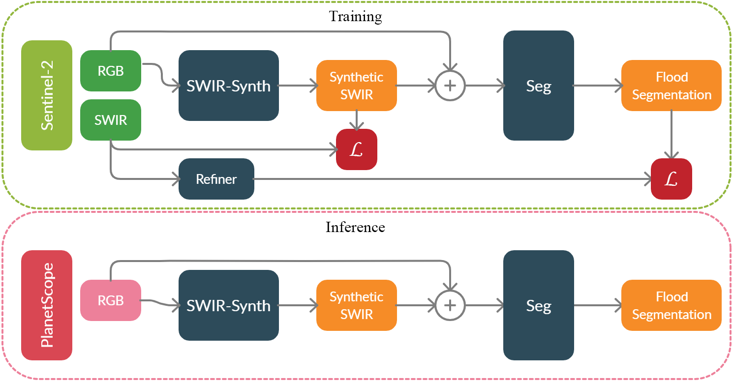
H2O-Net training and inference pipelines. H2O-Net uses Sentinel-2 (low resolution) satellite data to learn synthetic SWIR_{2} signals and flood segmentation self-supervised by refined ground truth. It is then evaluated on PlanetScope (high resolution) data

Overview of self-supervision architecture. High confidence points are first sampled from MNDWI and are used to obtain adaptive distance map and as ground truth to the refiner network. Adaptive distance map is concatenated to MNDWI as a 2 channel input to the refiner network. Blue and red dots represent points sampled from water and non-water pixels respectively. Best viewed in color.
Abstract
Accurate flood detection in near real time via high resolution, high latency satellite imagery is essential to prevent loss of lives by providing quick and actionable information. Instruments and sensors useful for flood detection are rarely available in low resolution, low latency satellites with region re-visit periods of up to 16 days, making flood alerting systems that use such satellite unreliable. Accurate flood detection in near real time via high resolution, high latency satellite imagery is essential to prevent loss of lives by providing quick and actionable information. Instruments and sensors useful for flood detection are rarely available in low resolution, low latency satellites with region re-visit periods of up to 16 days, making flood alerting systems that use such satellite unreliable. This work presents H2O-Network, a self supervised deep learning method to segment floods from satellites and aerial imagery by bridging domain gap between low and high latency satellite and coarse-to-fine label refinement. H2O-Net learns to synthesize signals highly correlative with water presence as a domain adaptation step for semantic segmentation in high resolution satellite imagery. Our work also proposes a self-supervision mechanism, which does not require any hand annotation, used during training to generate high quality ground truth data. We demonstrate that H2O-Net outperforms the state-of-the-art semantic segmentation methods on satellite imagery by 16.43% for the task of flood segmentation. We also show that our method may be beneficial to other domains that make use of reflectance properties.
Video
Paper

Paper and Supplement (Arxiv)
@misc{akiva2020h2onet,
title={H2O-Net: Self-Supervised Flood Segmentation via Adversarial Domain Adaptation and Label Refinement},
author={Peri Akiva and Matthew Purri and Kristin Dana and Beth Tellman and Tyler Anderson},
eprint={2010.05309},
archivePrefix={arXiv},
primaryClass={cs.CV}
year = {2020}